
- SAP Community
- Products and Technology
- Technology
- Technology Blogs by SAP
- Don’t Let Physical Locations Hamper Your Spatial V...
Technology Blogs by SAP
Learn how to extend and personalize SAP applications. Follow the SAP technology blog for insights into SAP BTP, ABAP, SAP Analytics Cloud, SAP HANA, and more.
Turn on suggestions
Auto-suggest helps you quickly narrow down your search results by suggesting possible matches as you type.
Showing results for
Advisor
Options
- Subscribe to RSS Feed
- Mark as New
- Mark as Read
- Bookmark
- Subscribe
- Printer Friendly Page
- Report Inappropriate Content
07-10-2018
2:52 PM
Data is the digital currency of the Intelligent Enterprise and spatial data has become an extremely critical and relevant component. Organizations that leverage spatial & enterprise data together have a clear competitive advantage and differentiation. By combining business with geographical information, enterprises achieve better insight, make better business decisions, are more innovative, and ultimately drive spatial into their core business processes.
SAP HANA provides an extremely powerful platform to process all kinds of enterprise data, structured & unstructured, including spatial data. Specifically, the SAP HANA spatial engine provides extreme performance, simplicity, and agility for creating that next-generation application as well as supporting third-party geospatial & GIS platforms, like Esri ArcGIS.
Earlier this year it was announced that SAP HANA is a supported Enterprise Geodatabase for Esri. This provides a tremendous value proposition for joint SAP & Esri customers by providing one platform for both enterprise & GIS. Customers leveraging SAP HANA with Esri & SAP are seeing higher performance, reduced TCO, and seamless integration of enterprise and GIS data.
To further improve ROI and increase agility, the latest release of the SAP Cloud Platform, SAP HANA service was launched at SAPPHIRE 2018. This “next generation” of SAP HANA was developed based on cloud-first principles, both technically and commercially. It provides for instant provisioning, multi-cloud deployment on various third-party hyperscaler providers of your choosing, elastic scalability, consumption based pricing, and is fully maintained by SAP. Best of all, it’s still the same powerful SAP HANA platform you’ve experienced before with its advanced capabilities like graph, spatial, predictive, text analysis & mining, and machine learning.
You can now easily spin-up SAP HANA instances in the cloud to create those innovative solutions, run advanced analytics, create custom applications & application extensions, and use for spatial scenarios with Esri ArcGIS. These include Esri use cases for geodatabase, query layers, and Insights for Esri ArcGIS. Many scenarios requiring spatial data can benefit greatly from this agility, so we are proud that SAP HANA as a Service can be leveraged for Esri ArcGIS scenarios.
Cloud can bring more flexibility and scalability to spatial scenarios.
Take, for example, the scenario below SAP built with Esri ArcGIS and SAP, showcased at SAPPHIRE in Hasso Plattner’s keynote. It shows how a utility planner can proactively determine and upgrade transformers based on expected electronic vehicle sales and the transformer load that would result.
SAP HANA’s predictive capabilities are used to determine the future electronic vehicle sales using Esri’s Tapestry data as one of the inputs. Demographic data groups neighbourhoods into “Professional Pride” and “Bright Young Professionals”, which helps predict electric vehicle sales in the neighborhood.

(A high-level overview allows the utility planner to easily identify hot spots)

(Drill down to see demographic information about a neighborhood and resolved and expected outages)
Using the Esri ArcGIS Network Utility Model, this scenario is used to determine which transformers feed a neighborhood (called tracing). By neighborhood it then determines what load the expected electronic vehicles would place on a given transformer—and which should be replaced before they fail and cause an outage.
Then the SAP Service Ticket Intelligence Insights capability and Ruum by SAP, SAP’s simple project management overlay, are used to collaborate and take proactive actions.
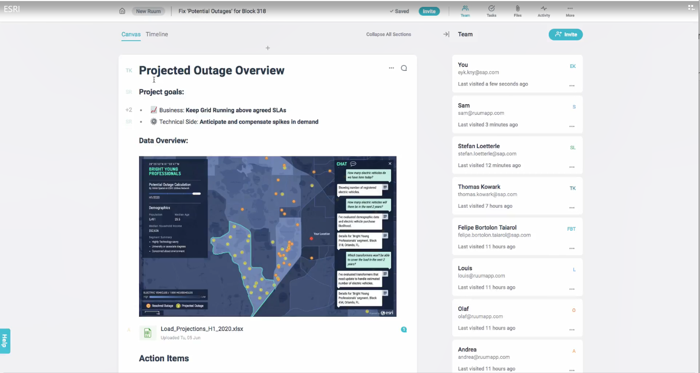
(Share the information easily in collaboration tools)
You can watch the full demonstration in the recording of Hasso Plattner’s SAPPHIRE keynote (starting at 1:19)
In this example the electric distribution data is located in Florida, but the utility planning application could be used in multiple regions. If the company wanted to deploy this application in a different region they may choose to deploy to a local datacenter in a public cloud provider. This develop once, deploy anywhere notion increases the speed at which new areas could be analyzed and extra SAP HANA capacity can be added easily in the cloud without needing to purchase, deploy, and maintain hardware. And it’s possible that the application could be used for a temporary amount of time, in cloud scenarios you can “spin down” instances when not in use so you aren’t paying for capacity you don’t need.
More information on connecting Esri ArcGIS to SAP HANA can be found in this blog, here’s a tutorial on connecting SAP HANA as a Service ODBC client access. Why do you want to do this? Easy—you get all of the benefits of SAP HANA as your enterprise geodatabase for Esri ArcGIS without the installation and management requirements. Start fast, scale up quickly, and leave the management to SAP Cloud Platform.
You can learn more and see live demos at the ESRI User Conference July 9-13 at booth 601.
SAP HANA provides an extremely powerful platform to process all kinds of enterprise data, structured & unstructured, including spatial data. Specifically, the SAP HANA spatial engine provides extreme performance, simplicity, and agility for creating that next-generation application as well as supporting third-party geospatial & GIS platforms, like Esri ArcGIS.
Earlier this year it was announced that SAP HANA is a supported Enterprise Geodatabase for Esri. This provides a tremendous value proposition for joint SAP & Esri customers by providing one platform for both enterprise & GIS. Customers leveraging SAP HANA with Esri & SAP are seeing higher performance, reduced TCO, and seamless integration of enterprise and GIS data.
To further improve ROI and increase agility, the latest release of the SAP Cloud Platform, SAP HANA service was launched at SAPPHIRE 2018. This “next generation” of SAP HANA was developed based on cloud-first principles, both technically and commercially. It provides for instant provisioning, multi-cloud deployment on various third-party hyperscaler providers of your choosing, elastic scalability, consumption based pricing, and is fully maintained by SAP. Best of all, it’s still the same powerful SAP HANA platform you’ve experienced before with its advanced capabilities like graph, spatial, predictive, text analysis & mining, and machine learning.
You can now easily spin-up SAP HANA instances in the cloud to create those innovative solutions, run advanced analytics, create custom applications & application extensions, and use for spatial scenarios with Esri ArcGIS. These include Esri use cases for geodatabase, query layers, and Insights for Esri ArcGIS. Many scenarios requiring spatial data can benefit greatly from this agility, so we are proud that SAP HANA as a Service can be leveraged for Esri ArcGIS scenarios.
Cloud can bring more flexibility and scalability to spatial scenarios.
Take, for example, the scenario below SAP built with Esri ArcGIS and SAP, showcased at SAPPHIRE in Hasso Plattner’s keynote. It shows how a utility planner can proactively determine and upgrade transformers based on expected electronic vehicle sales and the transformer load that would result.
SAP HANA’s predictive capabilities are used to determine the future electronic vehicle sales using Esri’s Tapestry data as one of the inputs. Demographic data groups neighbourhoods into “Professional Pride” and “Bright Young Professionals”, which helps predict electric vehicle sales in the neighborhood.
(A high-level overview allows the utility planner to easily identify hot spots)
(Drill down to see demographic information about a neighborhood and resolved and expected outages)
Using the Esri ArcGIS Network Utility Model, this scenario is used to determine which transformers feed a neighborhood (called tracing). By neighborhood it then determines what load the expected electronic vehicles would place on a given transformer—and which should be replaced before they fail and cause an outage.
Then the SAP Service Ticket Intelligence Insights capability and Ruum by SAP, SAP’s simple project management overlay, are used to collaborate and take proactive actions.
(Share the information easily in collaboration tools)
You can watch the full demonstration in the recording of Hasso Plattner’s SAPPHIRE keynote (starting at 1:19)
In this example the electric distribution data is located in Florida, but the utility planning application could be used in multiple regions. If the company wanted to deploy this application in a different region they may choose to deploy to a local datacenter in a public cloud provider. This develop once, deploy anywhere notion increases the speed at which new areas could be analyzed and extra SAP HANA capacity can be added easily in the cloud without needing to purchase, deploy, and maintain hardware. And it’s possible that the application could be used for a temporary amount of time, in cloud scenarios you can “spin down” instances when not in use so you aren’t paying for capacity you don’t need.
More information on connecting Esri ArcGIS to SAP HANA can be found in this blog, here’s a tutorial on connecting SAP HANA as a Service ODBC client access. Why do you want to do this? Easy—you get all of the benefits of SAP HANA as your enterprise geodatabase for Esri ArcGIS without the installation and management requirements. Start fast, scale up quickly, and leave the management to SAP Cloud Platform.
You can learn more and see live demos at the ESRI User Conference July 9-13 at booth 601.
- SAP Managed Tags:
- SAP Datasphere,
- SAP HANA
Labels:
You must be a registered user to add a comment. If you've already registered, sign in. Otherwise, register and sign in.
Labels in this area
-
ABAP CDS Views - CDC (Change Data Capture)
2 -
AI
1 -
Analyze Workload Data
1 -
BTP
1 -
Business and IT Integration
2 -
Business application stu
1 -
Business Technology Platform
1 -
Business Trends
1,658 -
Business Trends
93 -
CAP
1 -
cf
1 -
Cloud Foundry
1 -
Confluent
1 -
Customer COE Basics and Fundamentals
1 -
Customer COE Latest and Greatest
3 -
Customer Data Browser app
1 -
Data Analysis Tool
1 -
data migration
1 -
data transfer
1 -
Datasphere
2 -
Event Information
1,400 -
Event Information
66 -
Expert
1 -
Expert Insights
177 -
Expert Insights
299 -
General
1 -
Google cloud
1 -
Google Next'24
1 -
Kafka
1 -
Life at SAP
780 -
Life at SAP
13 -
Migrate your Data App
1 -
MTA
1 -
Network Performance Analysis
1 -
NodeJS
1 -
PDF
1 -
POC
1 -
Product Updates
4,577 -
Product Updates
345 -
Replication Flow
1 -
RisewithSAP
1 -
SAP BTP
1 -
SAP BTP Cloud Foundry
1 -
SAP Cloud ALM
1 -
SAP Cloud Application Programming Model
1 -
SAP Datasphere
2 -
SAP S4HANA Cloud
1 -
SAP S4HANA Migration Cockpit
1 -
Technology Updates
6,873 -
Technology Updates
427 -
Workload Fluctuations
1
Related Content
- Expanding Our Horizons: SAP's Build-Out and Datacenter Strategy for SAP Business Technology Platform in Technology Blogs by SAP
- Demystifying the Common Super Domain for SAP Mobile Start in Technology Blogs by SAP
- Empowering Retail Business with a Seamless Data Migration to SAP S/4HANA in Technology Blogs by Members
- 10+ ways to reshape your SAP landscape with SAP Business Technology Platform - Blog 5 in Technology Blogs by SAP
- Part 2:- SAP Basis OS support on SUSE Linux for beginners in Technology Blogs by Members
Top kudoed authors
| User | Count |
|---|---|
| 41 | |
| 25 | |
| 17 | |
| 14 | |
| 9 | |
| 7 | |
| 6 | |
| 6 | |
| 6 | |
| 6 |