
- SAP Community
- Products and Technology
- Technology
- Technology Blogs by SAP
- SAP + Esri Hackathon: Coding with a purpose
Technology Blogs by SAP
Learn how to extend and personalize SAP applications. Follow the SAP technology blog for insights into SAP BTP, ABAP, SAP Analytics Cloud, SAP HANA, and more.
Turn on suggestions
Auto-suggest helps you quickly narrow down your search results by suggesting possible matches as you type.
Showing results for
Former Member
Options
- Subscribe to RSS Feed
- Mark as New
- Mark as Read
- Bookmark
- Subscribe
- Printer Friendly Page
- Report Inappropriate Content
03-09-2018
3:37 AM
SAP and Esri, the global leader in geographic information systems (GIS) and spatial analytics, can look back on a long-standing partnership with the aim to further help companies leverage the power of location to uncover new insights from business, social, and sensor data. Just recently, we announced that Esri now supports SAP HANA as a certified enterprise geodatabase – an achievement both companies have been striving for. Make sure you check out this blog by Daniel Schneiss to learn more about how SAP and Esri are taking geospatial analytics to the next level.
As part of this, the first SAP + Esri Spatial Hackathon took place March 3-5. Immediately preceding the Esri Developer Summit, GIS Developers, Enterprise Architects, BI Developers, and students got together, accompanied by 10 technical experts from both SAP and Esri, for 40+ hours to solve three challenges:
Solving the toughest challenges
The SAP Co-Innovation Lab provided a robust infrastructure for the teams to use, and the results were simply amazing. One team was inspired by the response to the hurricanes in Puerto Rico. Although many aide items of food, water, and supplies were sent to Puerto Rico, it was very difficult to get these supplies to the people that needed them most. The team used SAP HANA’s spatial, graph and text capabilities with ArcGIS Pro and ArcGIS Enterprise to more effectively distribute goods given current travel conditions. Another team used ArcGIS and SAP HANA to suggest new traffic routes when inclement weather hit.
At the end, the race was so close that we had two teams exactly tied for finalists.
Finalist team Spatial Forces was comprised of students from University of California, Santa Barbara. Given their location in California, they were concerned with earthquakes. The team developed risk models for buildings in the Bay Area, and parameterized the result based on social norms (accounting for residences when people are at work, for example). Spatial Forces used Esri to classify building type and land use, access and visualize reclassified coverage, and enhanced this with living atlas. SAP HANA was used to store 3 million buildings for the city of San Francisco, and 216 simulated earthquakes. Finally, the intensity data was visualized using SAP Analytics Cloud.
Finalist team We’re Working on It was a corporate team from Southern California Edison (SCE), the primary electricity supply company for much of Southern California. This team developed a solution to predict grid usage for solar, using SAP HANA, ArcGIS Pro, and R to show which parts of the grid may need modernization to maintain reliability and support clean energy. The picture below shows the SAP HANA enterprise geodatabase data in ArcGIS Pro.

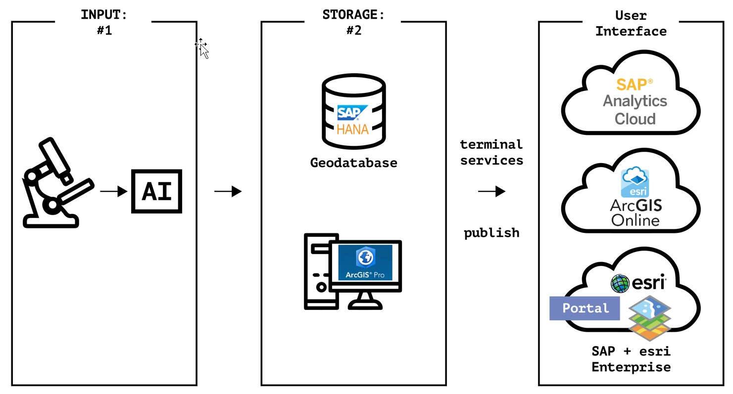
In addition to the two finalists, the Grand Prize winner team Brontosaurus (aka Safety of Water) brought a microscope and trained a machine learning model to recognize quality water. They were inspired by the water quality crisis in Flint, Michigan, and wanted to provide more real-time, automated water quality maps. Team Brontosaurus used tea water and clean water to train a machine learning model that could identify clean water. These results were stored in the SAP HANA enterprise geodatabase for Esri ArcGIS. Analytics were then published to SAP Analytics Cloud and ArcGIS Online.
For example, you can see analytics of safe water (identified by the machine learning model), and then show where this water is on a map.

SAP + Esri = Amazing
During the whole hackathon, participants were consistently surprised with SAP HANA as an Esri geodatabase. Most participants had little to none experience with SAP HANA prior to the event. Their initial perception of “complicated” and “heavy as a rock” was soon replaced by “this is amazing!” and “why didn’t anyone tell me how fast it is!”
For details on the SAP and Esri integration, check Tom Turchioe’s blog. Stay tuned to the #SAPEsri tag to hear about upcoming webinars and podcasts. Make sure you also visit the Esri booth at SAPPHIRE in June, and the SAP booth at the Esri User Conference in July.
Interested to get started now? Check out the ArcGIS Pro version for SAP HANA, Express Edition (HXE)—free trial edition and find out more, including new tutorials and content.
As part of this, the first SAP + Esri Spatial Hackathon took place March 3-5. Immediately preceding the Esri Developer Summit, GIS Developers, Enterprise Architects, BI Developers, and students got together, accompanied by 10 technical experts from both SAP and Esri, for 40+ hours to solve three challenges:
- Spatial & Graph: Process and visualize topologies and networks. Combine the capabilities of SAP HANA and Esri for innovative approaches to network analytics.
- Sustain, create, optimize: Improve and optimize daily business using spatial analytics while also meeting sustainable development goals.
- Geo machine learning: Illustrate how AI and machine learning can benefit from the spatial dimension. How can we use machine learning in spatial analytics to solve major challenges?
Solving the toughest challenges
The SAP Co-Innovation Lab provided a robust infrastructure for the teams to use, and the results were simply amazing. One team was inspired by the response to the hurricanes in Puerto Rico. Although many aide items of food, water, and supplies were sent to Puerto Rico, it was very difficult to get these supplies to the people that needed them most. The team used SAP HANA’s spatial, graph and text capabilities with ArcGIS Pro and ArcGIS Enterprise to more effectively distribute goods given current travel conditions. Another team used ArcGIS and SAP HANA to suggest new traffic routes when inclement weather hit.
At the end, the race was so close that we had two teams exactly tied for finalists.
Finalist team Spatial Forces was comprised of students from University of California, Santa Barbara. Given their location in California, they were concerned with earthquakes. The team developed risk models for buildings in the Bay Area, and parameterized the result based on social norms (accounting for residences when people are at work, for example). Spatial Forces used Esri to classify building type and land use, access and visualize reclassified coverage, and enhanced this with living atlas. SAP HANA was used to store 3 million buildings for the city of San Francisco, and 216 simulated earthquakes. Finally, the intensity data was visualized using SAP Analytics Cloud.
Finalist team We’re Working on It was a corporate team from Southern California Edison (SCE), the primary electricity supply company for much of Southern California. This team developed a solution to predict grid usage for solar, using SAP HANA, ArcGIS Pro, and R to show which parts of the grid may need modernization to maintain reliability and support clean energy. The picture below shows the SAP HANA enterprise geodatabase data in ArcGIS Pro.
In addition to the two finalists, the Grand Prize winner team Brontosaurus (aka Safety of Water) brought a microscope and trained a machine learning model to recognize quality water. They were inspired by the water quality crisis in Flint, Michigan, and wanted to provide more real-time, automated water quality maps. Team Brontosaurus used tea water and clean water to train a machine learning model that could identify clean water. These results were stored in the SAP HANA enterprise geodatabase for Esri ArcGIS. Analytics were then published to SAP Analytics Cloud and ArcGIS Online.
For example, you can see analytics of safe water (identified by the machine learning model), and then show where this water is on a map.
SAP + Esri = Amazing
During the whole hackathon, participants were consistently surprised with SAP HANA as an Esri geodatabase. Most participants had little to none experience with SAP HANA prior to the event. Their initial perception of “complicated” and “heavy as a rock” was soon replaced by “this is amazing!” and “why didn’t anyone tell me how fast it is!”
For details on the SAP and Esri integration, check Tom Turchioe’s blog. Stay tuned to the #SAPEsri tag to hear about upcoming webinars and podcasts. Make sure you also visit the Esri booth at SAPPHIRE in June, and the SAP booth at the Esri User Conference in July.
Interested to get started now? Check out the ArcGIS Pro version for SAP HANA, Express Edition (HXE)—free trial edition and find out more, including new tutorials and content.
- SAP Managed Tags:
- SAP Datasphere,
- SAP HANA
Labels:
You must be a registered user to add a comment. If you've already registered, sign in. Otherwise, register and sign in.
Labels in this area
-
ABAP CDS Views - CDC (Change Data Capture)
2 -
AI
1 -
Analyze Workload Data
1 -
BTP
1 -
Business and IT Integration
2 -
Business application stu
1 -
Business Technology Platform
1 -
Business Trends
1,661 -
Business Trends
87 -
CAP
1 -
cf
1 -
Cloud Foundry
1 -
Confluent
1 -
Customer COE Basics and Fundamentals
1 -
Customer COE Latest and Greatest
3 -
Customer Data Browser app
1 -
Data Analysis Tool
1 -
data migration
1 -
data transfer
1 -
Datasphere
2 -
Event Information
1,400 -
Event Information
64 -
Expert
1 -
Expert Insights
178 -
Expert Insights
273 -
General
1 -
Google cloud
1 -
Google Next'24
1 -
Kafka
1 -
Life at SAP
784 -
Life at SAP
11 -
Migrate your Data App
1 -
MTA
1 -
Network Performance Analysis
1 -
NodeJS
1 -
PDF
1 -
POC
1 -
Product Updates
4,577 -
Product Updates
326 -
Replication Flow
1 -
RisewithSAP
1 -
SAP BTP
1 -
SAP BTP Cloud Foundry
1 -
SAP Cloud ALM
1 -
SAP Cloud Application Programming Model
1 -
SAP Datasphere
2 -
SAP S4HANA Cloud
1 -
SAP S4HANA Migration Cockpit
1 -
Technology Updates
6,886 -
Technology Updates
403 -
Workload Fluctuations
1
Related Content
- Consolidation Extension for SAP Analytics Cloud – Automated Eliminations and Adjustments (part 1) in Technology Blogs by Members
- AutoGen with SAP AI Core in Technology Blogs by SAP
- Consolidation Extension for SAP Analytics Cloud – Detailed Currency Conversion in Technology Blogs by Members
- SAP Build Code: purpose of .code files in Technology Q&A
- First hand experience at SAP Build Code - Learn, Try it out, Get a badge, SAP Discovery Centre in Technology Blogs by SAP
Top kudoed authors
| User | Count |
|---|---|
| 12 | |
| 10 | |
| 9 | |
| 7 | |
| 7 | |
| 7 | |
| 6 | |
| 6 | |
| 5 | |
| 4 |