
- SAP Community
- Groups
- Interest Groups
- Sustainability
- Blogs
- SAP Digital Farming sneak preview
Sustainability Blogs
Delve into SAP sustainability blogs. Gain insights into tech-driven sustainable practices and contribute to a greener future for businesses and the planet.
Turn on suggestions
Auto-suggest helps you quickly narrow down your search results by suggesting possible matches as you type.
Showing results for
Employee
Options
- Subscribe to RSS Feed
- Mark as New
- Mark as Read
- Bookmark
- Subscribe
- Printer Friendly Page
- Report Inappropriate Content
06-17-2015
11:15 PM
As part SAP’s Networked Economy Forum taking place in Paris, France this June 17th and 18th, it has been my privilege to be given the opportunity to demo our brand new application SAP Digital Farming.
This application is just stunning, and has been given a warm welcome by all our guests on this first day of the Forum. And one can see why.
It addresses the needs of farmers, and beyond this, one topic concerning us all, that is food production, and how to make it more efficient, less resource-intensive, economically viable for the farmers while more eco-friendly for the planet. This equation has always seemed elusive to resolve up to now. But finally the agility and power of HANA as an IoT platform is bringing key answers in the path to solve those issues.
SAP Digital farming provides a satellite map of the entire farm (fig. 1).
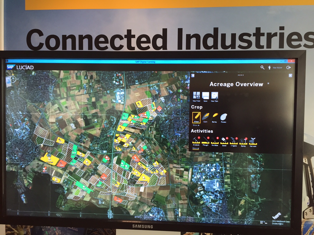
Fig. 1 - Farm overview
Using geo-fencing, it allows farmers to zoom on each plot constituting the farm where they can immediately see information pertaining to that particular piece of land: crop, humidity level, real-time standing of work taking place in the field, phytosanitary health of the plants, etc.
Information is streamed back to the platform either by sensors physically installed on the land (such as humidity sensors), and/or human action (Ex: pest or fungus detection) sent back through a mobile device. Fig. 2 shows such detailed view.

Fig. 2 - Plots of land in detail
Additionally, the platform also receives real-time weather data (Fig. 3), alerting the farmer of potentially dangerous weather episodes for his crops: hail, gusts of wind, storm, etc.

Fig. 3 - Weather forecast
Predictive analysis allows the system to calculate the future impact on the fields of such events (Fig. 4)

Fig. 4 - Affected plots of land by weather event (flooded plots in this case)
Using HANA to process all this data and SAP Lumira for decision support, the farmer can then choose where and when to fertilize and what concentration of nitrates to use (depending on the soil analysis: e.g. chalky soils will need more fertilizer than argillaceous ones). He can water the fields with the exact amount of water needed by the crop, thus allowing precious saving in drought areas. Finally, he can spray pesticides only on those plots that really need it, and not as a global preemptive action on all the fields as previously.
The impacts are numerous: lower water consumption, lower and optimal fertilizer consumption, lower and targeted pesticide usage: all this not only makes economic sense, but of course also makes ecological sense.
Once a task needing to be done has been identified by the system, the farmer can dispatch it to subcontractors working in his fields. It can be his own network of farm workers, or he can contact them through the Business Network. (See Fig. 5).

Fig. 5 – Affecting a task to a subcontractor
Using GPS, and tractor sensors, SAP Digital Farming can track work’s progress and visualize it in real time. The farmer can then monitor all the tasks taking place, which are assigned to his different fields.
For example, in Fig. 6, one can see in real-time a tractor spreading fertilizer in the field. The color coding corresponds to different concentration of nitrates applied depending on the quality of the soil.

Fig. 6 – Tractor action in one plot.
Multiple applications of this technology can be considered, and discussions with partners and customers have been lively at the booth as the potential of the tool is huge. For example delegates from an African country were interested into the opportunity using it for better land and water distribution, but at the scale of a whole country! Agricultural cooperatives to offer new services to their members, helping them optimize their land use and increase the crop yields. Finally, it could be a great tool for winegrowers, especially in area of very complex terroirs, such as Burgundy for example.
From a purely technical standpoint, SAP Digital Farming is built on HANA Cloud Platform (HCP), leveraging HANA’s GeoSpacial Engine (SAP’s partner Luciad (www.luciad.com) providing the real-time situational awareness geospatial software), SAP Vehicle Insights for farming equipment data stream, and SAP Lumira for real-time decision support and predictive analysis scenarios.
I hope that these few insights will raise your excitement on the tool as much as it has for me and I will be keeping track on its adoption in the field, and keep you posted on real life project that it will help to power.
- SAP Managed Tags:
- Life Sciences,
- Sustainability
5 Comments
You must be a registered user to add a comment. If you've already registered, sign in. Otherwise, register and sign in.
Labels in this area
-
Banking
1 -
BTP for Sustainability
2 -
Circular Design
1 -
Circular Economy
1 -
Compliance
1 -
CSRD
1 -
EPR
1 -
ESG
1 -
ESRS
1 -
Financial Services
1 -
Insurance
1 -
Packaging
1 -
PCAF
1 -
Picking Strategy
1 -
Plastic Taxes
1 -
Recyclability
1 -
SAP Analytics Cloud
1 -
SAP Cloud for Sustainable Enterprises
1 -
SAP Community
1 -
SAP Datasphere
1 -
SAP Profitability and Performance Management
1 -
SAP Responsible Design and Production
1 -
SAP SCT
1 -
SAP Sustainability Control Tower
2 -
SAP Sustainability Footprint Management
1 -
SCT
1 -
Sustainability
1 -
Sustainability Control Tower
1 -
Sustainable Finance
1