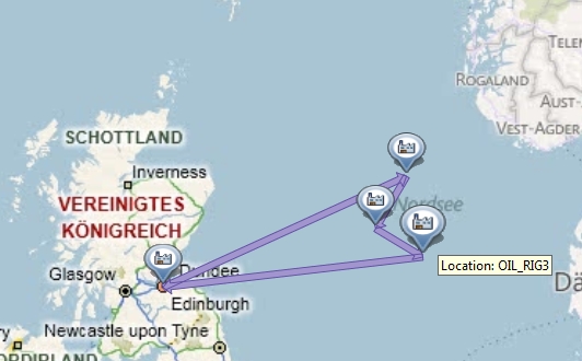
In the wild meaning between oil rigs, in the forest or desert. Actually anywhere where there is not really an address available. Hmm, gotta think about that.
Scenario must allow a flexible creation of Locations somewhere to create a fixed master data setup (oil rigs) or a complete dynamic setup (moving base in the desert) . Okay, that should work as only the country field of the address is mandatory. The identification of the Location (for example when entering an order) could work with a meaningful name. But where to get the coordinate from? Well, for each Location a call to the geo-coding is executed and as this is done in a customer specific implementation, a 'wild' coordinate could be determined here using specific Location attributes. The coordinate could even come from a GPS to track a mobile command center. Also it is probably a good idea to use the Geo-Map component here, which would allow to visualize the 'wild' or even capture the coordinate from there.
Okay, now we got 'wild' locations with accurate coordinates. How do we connect them to enable planning? And how to determine distance between them? Again, depends on the scenario. Maybe between oil rigs its fine to use schedules (includes connection and fixed distance / duration). For the dynamic scenario using Transportation Lanes we need to find a way to catch the 'wild' locations. Don't want to create a Lane for each Location - Location combination. But Transportation Zones only work dynamically using postal codes (we don't have one!!!) or regions. But couldn't we use regions?!?!?! Okay, the basic idea behind regions is to match somehow states. But in general you can maintain there (NetWeaver customizing) whatever you like. So why not map our desert / forest areas into regions and assign the right one when creating the Location. Again, great scenario for the Geo-Map.
For the distance determination the standard rules apply: Starting point is always straight line, which of course does not match reallity very good. But we can handle this in a specific implementation and improve the distance quality. Probably hard to find a good data source. Needs to be evaluated carefully.
Having the master data setup, SAP TM should from now on work fine in all scenarios. Not a complete check list though, still open points to further consider.
You can also follow: http://www.linkedin.com/groups/Monday-Knowledge-Snippet-MKS-02-3107838.S.108028050?qid=6f8d2ee5-df56...