
- SAP Community
- Products and Technology
- Additional Blogs by Members
- Geocode Business Partner with Google Maps
Additional Blogs by Members
Turn on suggestions
Auto-suggest helps you quickly narrow down your search results by suggesting possible matches as you type.
Showing results for
gregorw
Active Contributor
Options
- Subscribe to RSS Feed
- Mark as New
- Mark as Read
- Bookmark
- Subscribe
- Printer Friendly Page
- Report Inappropriate Content
06-27-2006
5:13 AM
*Update Oct, 13th 2006:* Google Maps are now also avaliable for Enterprise use (http://www.google.com/enterprise/maps/index.html). *Update:* Have also a look at {code:html}Geocoding - the next step: Routing with Map24 AJAX API{code} Inspired by Eddy De Clercq’s (Eddy%20De%20Clercq's) SDN World Map (http://sdn.idizaai.be/sdn_world/sdn_world.html) and the German Podcast Pimp My Brain (http://tellerrand.typepad.com/tellerrand/pimp_my_brain/index.html) where they introduced me into Google Maps (http://www.google.com/apis/maps/) I’ve tried out to combine this with our SAP CRM People Centric User Interface (PC-UI). The result is this little BSP application which uses ABAP Object Persistence Service (http://help.sap.com/saphelp_nw04/helpdata/en/f5/a36828bc6911d4b2e80050dadfb92b/frameset.htm) and Simple Transformations (Fifth ABAP Online Meet-up: Simple Transformations). During my research about geocoding in a SAP environment I found Geocoding for BW (http://help.sap.com/saphelp_erp2004/helpdata/en/3b/7c93ec1bed374ee0000800091c1b0e/frameset.htm) and Geocoding for Business Partners (http://help.sap.com/saphelp_erp2004/helpdata/en/19/0353f6e7689b43a43615e25655eeb4/frameset.htm). You find more information about this topic in the SPRO customizing transaction at SAP NetWeaver -> General Settings -> Set Geocoding. Unfortunately I’ve found no documentation how to implement this standard interface and I implemented my own. External Geocoding solutions can be found in the Partner Directory Solution Search (http://www.sap.com/partners/directories/SearchSolution.epx). SAP Notes regarding Geocoding can be found in the OSS Application Area BC-SRV-GEO. There is also an SDN Article “[Using Geo Services with Web Dynpro | https://www.sdn.sap.com/irj/servlet/prt/portal/prtroot/com.sap.km.cm.docs/library/webdynpro/using%20... which uses the standard interface which calls external providers using the IGS. But now let’s start to build our solution which will result in:  h3. Preparation h4. Sign up to the Google Maps API To use Google Maps (http://www.google.com/apis/maps/) you have to Sign up for the Google Maps API (http://www.google.com/apis/maps/signup.html). You have to provide the web site URL which must exactly match your WebAS URL including the Port. I. e. http://webas.test.com:8000/. After the sign up you get a sample HTML Source which you can save locally and play around using the API Documentation (http://www.google.com/apis/maps/documentation/).
h4. Create Database Table for Geocoding Data I’ve put all development objects together in the Package ZBPGOOGLEMAP: Here I’ve created also the DB Table ZBPGEOCODE which will contain the Geocode information for a Business Partner (BP). To detect changes on the BP I also save Street, Street No., Postal Code and City in this table.
  h4. Create Persistent class for Geocoding Data A long time ago I’ve read Thomas Jung (/people/thomas.jung/blog)’s Weblog on “[ABAP Persistent Classes: Coding without SQL | ABAP Persistent Classes: Coding without SQL]” but never tried it on my own. But here I’ve done it and created the Class ZCL_BPGEOCODE which is from Class Type “Persistent class”. All the rest is described in detail in the mentioned Blog. Be aware that you have to use the DB Table ZBPGEOCODE.
h4. Transform Google KML to ABAP I did not attend the ABAP Online Meet-up on Simple Transformations (Fifth ABAP Online Meet-up: Simple Transformations) but it inspired me to use this to transform the return of the Geocoding HTTP Request (http://www.google.com/apis/maps/documentation/#Geocoding_HTTP_Request) into an ABAP Structure. To test the Transformation I first downloaded the result of this request to my local drive: http://maps.google.com/maps/geo?q=Neurottstr.+15a,+Walldorf,+DE&output=xml&key=... h3. Implement the BSP * event handler for checking and processing user input and * for defining navigation DATA: ls_addressdata TYPE bapibus1006_address. IF NOT bp IS INITIAL. * Get leading zeros for BP Number CALL FUNCTION 'BAPI_BUPA_GET_NUMBERS' EXPORTING businesspartner = bp IMPORTING businesspartnerout = bp. * Get BP's default address CALL FUNCTION 'BAPI_BUPA_ADDRESS_GETDETAIL' EXPORTING businesspartner = bp IMPORTING addressdata = ls_addressdata. * Prepare the address to display in marker CONCATENATE ls_addressdata-street ls_addressdata-house_no ' ' ls_addressdata-postl_cod1 ls_addressdata-city INTO address SEPARATED BY space. * Prepare the address as a Google Maps destination CONCATENATE ls_addressdata-street ls_addressdata-house_no ',' ls_addressdata-postl_cod1 ls_addressdata-city INTO mapadd SEPARATED BY '%20'. * Get Users Address as the from address data: USER_ADDRESS type ADDR3_VAL. CALL FUNCTION 'SUSR_USER_ADDRESS_READ' EXPORTING user_name = sy-uname IMPORTING USER_ADDRESS = USER_ADDRESS. CONCATENATE USER_ADDRESS-street USER_ADDRESS-house_num1 ',' USER_ADDRESS-post_code1 USER_ADDRESS-city1 INTO fromadd SEPARATED BY '%20'. * Check if Geocoding for address already exists DATA: geocode TYPE zbpgeocode. DATA: connection TYPE REF TO zcl_bpgeocode, agent TYPE REF TO zca_bpgeocode. DATA: exc TYPE REF TO cx_root, getgeocode TYPE flag, updategeocode TYPE flag. agent = zca_bpgeocode=>agent. TRY. * Get Persistence Object by Key connection = agent->get_persistent( i_partner = bp ). * Has the Address been changed? IF ls_addressdata-street = connection->get_street( ) AND ls_addressdata-house_no = connection->get_house_no( ) AND ls_addressdata-postl_cod1 = connection->get_postl_cod1( ) AND ls_addressdata-city = connection->get_city( ). geocode-lon = connection->get_lon( ). geocode-lat = connection->get_lat( ). geocode-alt = connection->get_alt( ). ELSE. * Address was changed and needs to be updated getgeocode = 'X'. updategeocode = 'X'. ENDIF. * Object does not exist. So we have to get the geocode CATCH cx_root INTO exc. getgeocode = 'X'. ENDTRY. IF getgeocode = 'X'. * HTTP Client according to * BSP: Create a weather magnet using xml feed from weather.com DATA: client TYPE REF TO if_http_client, url TYPE string, c_xml TYPE string. * Build URL to call Googe Maps Geocoding url = 'http://maps.google.com/maps/geo?q='. IF NOT ls_addressdata-house_no IS INITIAL. CONCATENATE url ls_addressdata-house_no '+' INTO url. ENDIF. CONCATENATE url ls_addressdata-street ',' INTO url. CONCATENATE url ls_addressdata-postl_cod1 ',' ls_addressdata-city ',' ls_addressdata-countryiso '&output=xml' '&key=...' INTO url. ****Create the HTTP client CALL METHOD cl_http_client=>create_by_url EXPORTING url = url IMPORTING client = client EXCEPTIONS OTHERS = 1. client->send( ). client->receive( ). ****Get the response content in Character format c_xml = client->response->get_cdata( ). ****Transform XML to ABAP Values CALL TRANSFORMATION zgoogle_geocode_to_abap SOURCE XML c_xml RESULT geocode = geocode. IF NOT geocode IS INITIAL. MOVE-CORRESPONDING ls_addressdata TO geocode. geocode-partner = bp. geocode-erzet = sy-uzeit. geocode-erdat = sy-datum. IF updategeocode = 'X'. * Update Persistent Object connection->set_erzet( geocode-erzet ). connection->set_erdat( geocode-erdat ). connection->set_lon( geocode-lon ). connection->set_lat( geocode-lat ). connection->set_alt( geocode-alt ). connection->set_street( geocode-street ). connection->set_house_no( geocode-house_no ). connection->set_postl_cod1( geocode-postl_cod1 ). connection->set_city( geocode-city ). COMMIT WORK. ELSE. * Create Persistent Object TRY. connection = agent->create_persistent( i_partner = geocode-partner i_erdat = geocode-erdat i_erzet = geocode-erzet i_lon = geocode-lon i_lat = geocode-lat i_alt = geocode-alt i_street = geocode-street i_house_no = geocode-house_no i_postl_cod1 = geocode-postl_cod1 i_city = geocode-city ). COMMIT WORK. ENDTRY. ENDIF. ENDIF. ENDIF. ENDIF. * Only fill Mapcenter if geocode is valid IF NOT geocode IS INITIAL. DATA: lat type string, lon type string. * Prepere Latitude for Javascript IF geocode-lat < 0. geocode-lat = geocode-lat * -1. lat = geocode-lat. CONCATENATE '-' lat INTO lat. ELSE. lat = geocode-lat. ENDIF. * Prepere Longitude for Javascript IF geocode-lon < 0. geocode-lon = geocode-lon * -1. lon = geocode-lon. CONCATENATE '-' lon INTO lon. ELSE. lon = geocode-lon. ENDIF. CONCATENATE lat ',' lon INTO mapcenter. ENDIF. Also here insert your own key to the generated URL. The result is this little BSP Application which provides a Map with a marker where our Business Partner is located.: After the extension suggested by Ranjan Kumar (https://www.sdn.sap.com/irj/servlet/prt/portal/prtroot/com.sap.sdn.businesscard.sdnbusinesscard?u=rm...) the layout is now:
 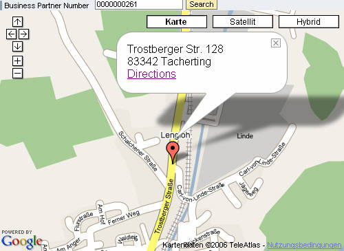 When you click on the "Directions" Link you see what Google suggests me to drive home.
h3. Preparation h4. Sign up to the Google Maps API To use Google Maps (http://www.google.com/apis/maps/) you have to Sign up for the Google Maps API (http://www.google.com/apis/maps/signup.html). You have to provide the web site URL which must exactly match your WebAS URL including the Port. I. e. http://webas.test.com:8000/. After the sign up you get a sample HTML Source which you can save locally and play around using the API Documentation (http://www.google.com/apis/maps/documentation/).h4. Create Database Table for Geocoding Data I’ve put all development objects together in the Package ZBPGOOGLEMAP:
Here I’ve created also the DB Table ZBPGEOCODE which will contain the Geocode information for a Business Partner (BP). To detect changes on the BP I also save Street, Street No., Postal Code and City in this table. h4. Create Persistent class for Geocoding Data A long time ago I’ve read Thomas Jung (/people/thomas.jung/blog)’s Weblog on “[ABAP Persistent Classes: Coding without SQL | ABAP Persistent Classes: Coding without SQL]” but never tried it on my own. But here I’ve done it and created the Class ZCL_BPGEOCODE which is from Class Type “Persistent class”. All the rest is described in detail in the mentioned Blog. Be aware that you have to use the DB Table ZBPGEOCODE.h4. Transform Google KML to ABAP I did not attend the ABAP Online Meet-up on Simple Transformations (Fifth ABAP Online Meet-up: Simple Transformations) but it inspired me to use this to transform the return of the Geocoding HTTP Request (http://www.google.com/apis/maps/documentation/#Geocoding_HTTP_Request) into an ABAP Structure. To test the Transformation I first downloaded the result of this request to my local drive: http://maps.google.com/maps/geo?q=Neurottstr.+15a,+Walldorf,+DE&output=xml&key=... h3. Implement the BSP * event handler for checking and processing user input and * for defining navigation DATA: ls_addressdata TYPE bapibus1006_address. IF NOT bp IS INITIAL. * Get leading zeros for BP Number CALL FUNCTION 'BAPI_BUPA_GET_NUMBERS' EXPORTING businesspartner = bp IMPORTING businesspartnerout = bp. * Get BP's default address CALL FUNCTION 'BAPI_BUPA_ADDRESS_GETDETAIL' EXPORTING businesspartner = bp IMPORTING addressdata = ls_addressdata. * Prepare the address to display in marker CONCATENATE ls_addressdata-street ls_addressdata-house_no ' ' ls_addressdata-postl_cod1 ls_addressdata-city INTO address SEPARATED BY space. * Prepare the address as a Google Maps destination CONCATENATE ls_addressdata-street ls_addressdata-house_no ',' ls_addressdata-postl_cod1 ls_addressdata-city INTO mapadd SEPARATED BY '%20'. * Get Users Address as the from address data: USER_ADDRESS type ADDR3_VAL. CALL FUNCTION 'SUSR_USER_ADDRESS_READ' EXPORTING user_name = sy-uname IMPORTING USER_ADDRESS = USER_ADDRESS. CONCATENATE USER_ADDRESS-street USER_ADDRESS-house_num1 ',' USER_ADDRESS-post_code1 USER_ADDRESS-city1 INTO fromadd SEPARATED BY '%20'. * Check if Geocoding for address already exists DATA: geocode TYPE zbpgeocode. DATA: connection TYPE REF TO zcl_bpgeocode, agent TYPE REF TO zca_bpgeocode. DATA: exc TYPE REF TO cx_root, getgeocode TYPE flag, updategeocode TYPE flag. agent = zca_bpgeocode=>agent. TRY. * Get Persistence Object by Key connection = agent->get_persistent( i_partner = bp ). * Has the Address been changed? IF ls_addressdata-street = connection->get_street( ) AND ls_addressdata-house_no = connection->get_house_no( ) AND ls_addressdata-postl_cod1 = connection->get_postl_cod1( ) AND ls_addressdata-city = connection->get_city( ). geocode-lon = connection->get_lon( ). geocode-lat = connection->get_lat( ). geocode-alt = connection->get_alt( ). ELSE. * Address was changed and needs to be updated getgeocode = 'X'. updategeocode = 'X'. ENDIF. * Object does not exist. So we have to get the geocode CATCH cx_root INTO exc. getgeocode = 'X'. ENDTRY. IF getgeocode = 'X'. * HTTP Client according to * BSP: Create a weather magnet using xml feed from weather.com DATA: client TYPE REF TO if_http_client, url TYPE string, c_xml TYPE string. * Build URL to call Googe Maps Geocoding url = 'http://maps.google.com/maps/geo?q='. IF NOT ls_addressdata-house_no IS INITIAL. CONCATENATE url ls_addressdata-house_no '+' INTO url. ENDIF. CONCATENATE url ls_addressdata-street ',' INTO url. CONCATENATE url ls_addressdata-postl_cod1 ',' ls_addressdata-city ',' ls_addressdata-countryiso '&output=xml' '&key=...' INTO url. ****Create the HTTP client CALL METHOD cl_http_client=>create_by_url EXPORTING url = url IMPORTING client = client EXCEPTIONS OTHERS = 1. client->send( ). client->receive( ). ****Get the response content in Character format c_xml = client->response->get_cdata( ). ****Transform XML to ABAP Values CALL TRANSFORMATION zgoogle_geocode_to_abap SOURCE XML c_xml RESULT geocode = geocode. IF NOT geocode IS INITIAL. MOVE-CORRESPONDING ls_addressdata TO geocode. geocode-partner = bp. geocode-erzet = sy-uzeit. geocode-erdat = sy-datum. IF updategeocode = 'X'. * Update Persistent Object connection->set_erzet( geocode-erzet ). connection->set_erdat( geocode-erdat ). connection->set_lon( geocode-lon ). connection->set_lat( geocode-lat ). connection->set_alt( geocode-alt ). connection->set_street( geocode-street ). connection->set_house_no( geocode-house_no ). connection->set_postl_cod1( geocode-postl_cod1 ). connection->set_city( geocode-city ). COMMIT WORK. ELSE. * Create Persistent Object TRY. connection = agent->create_persistent( i_partner = geocode-partner i_erdat = geocode-erdat i_erzet = geocode-erzet i_lon = geocode-lon i_lat = geocode-lat i_alt = geocode-alt i_street = geocode-street i_house_no = geocode-house_no i_postl_cod1 = geocode-postl_cod1 i_city = geocode-city ). COMMIT WORK. ENDTRY. ENDIF. ENDIF. ENDIF. ENDIF. * Only fill Mapcenter if geocode is valid IF NOT geocode IS INITIAL. DATA: lat type string, lon type string. * Prepere Latitude for Javascript IF geocode-lat < 0. geocode-lat = geocode-lat * -1. lat = geocode-lat. CONCATENATE '-' lat INTO lat. ELSE. lat = geocode-lat. ENDIF. * Prepere Longitude for Javascript IF geocode-lon < 0. geocode-lon = geocode-lon * -1. lon = geocode-lon. CONCATENATE '-' lon INTO lon. ELSE. lon = geocode-lon. ENDIF. CONCATENATE lat ',' lon INTO mapcenter. ENDIF. Also here insert your own key to the generated URL. The result is this little BSP Application which provides a Map with a marker where our Business Partner is located.:
After the extension suggested by Ranjan Kumar (https://www.sdn.sap.com/irj/servlet/prt/portal/prtroot/com.sap.sdn.businesscard.sdnbusinesscard?u=rm...) the layout is now: When you click on the "Directions" Link you see what Google suggests me to drive home.
17 Comments
Related Content
- IoT - Ultimate Data Cyber Security - with Enterprise Blockchain and SAP BTP 🚀 in Technology Blogs by Members
- Adverse Media Monitoring: How to improve overall Supply Chain Management in Supply Chain Management Blogs by Members
- Announcement: New integration platform in SAP Business Network for Logistics in Supply Chain Management Blogs by SAP
- Is it possible to change the names of multiple business partners at once? in Technology Q&A
- Accelerate Business Process Development with SAP Build Process Automation Pre-Built Content in Technology Blogs by SAP
Top kudoed authors
| User | Count |
|---|---|
| 1 | |
| 1 | |
| 1 | |
| 1 |